| Info
on some local popular Destinations:
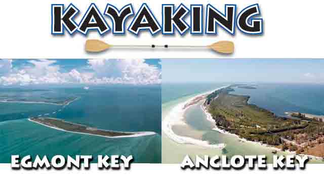
Kayaking
Egmont Key
I found kayaking to be one of my favorite
hobbies aside from surfing itself, it provides
people like me living in our area waiting for the surf to be
up again with something to do until then.
Living around the Tampa Bay area is great for the kayaker we
are so close to a chain of barrier islands
extending from Egmont key and ft. Desoto to Anclote key in the
tarpon springs area. If you like going to islands like this
living in our area is such an ideal place. My personal favorite
would be a tie between Egmont key and Anclote key depending
on how much of your day you would like to spend in
kayaking anywhere from 1-8 hours there is a lot to see. First
and the Southern most Key of our area Egmont lies in the middle
of the mouth of Tampa bay in between ft. Desoto and Anna Maria,
this exotic island is home to many gopher turtles and seagulls,almost
like a bus station in the middle of Tampa bay for the seagull's.
While kayaking to Egmont key I find the most efficient route
is from the South western tip of ft. Desoto right by the ruins
and the pier, there will be a radio tower to the right of the
pier, I suggest aiming for Egmont from this marker. Egmont is
roughly a mile, but the water gets very deep and sours to a
90 ft. drop in the channel so depending on currents and chop
I would expect your travel time to be 45 minutes for an experienced
and fast beach kayak to 1 hour and 10 minutes for the more moderate
or beginner. (If you are a beginner I would stick to a closer
island like shell island from)
I suggest bringing 1 gallon of water per person for this trip,
the current and switch very quickly and make your journey to
or from much longer than expected due to stronger currents,
I myself have had the journey there take 45 minutes but the
rough current back take me an hour and a half.
Once you begin to get closer to the island you may see Logger
head sea turtles which love Egmont and the deep channel for
feeding and breeding. Still to this day I have yet to see any
dolphins near Egmont, this is probably because its more of a
shark territory, the old myths of "Old Hitler"
(a 20 ft. hammer head) is said to be spotted in this area. But
even if you spot a shark in this area do not be surprised or
panic, you should feel privileged to see these animals up so
close.The Island Of Egmont has a pretty long history ranging
from belonging to the Indian's, the Spanish, The French, The
Spanish again and then Americans. There once was an old town
on this island if you venture inland
you will find a brick road that goes for about a mile through
the island, Only few houses or buildings remain some of which
are ruins. Most of which now are used by the wild life rangers
on the island. You will find signs that say take nothing but
pictures, leave nothing but foot prints. I do not recommend
bringing an open container of alcohol on this island, I have
seen the rangers write fines the Southwest point of the island
you will see ruins which once the rapidly changing coast line
of Egmont key once stood, this is excellent for snorkeling,
fishing. However the beach itself in this area is closed off
for the birds, so you need either a kayak or a boat for this
part. But once again this is shark territory. Egmont key is
ironically Hillsborough county, which once sued Pinellas county
tourism agency
for putting Egmont in one of its brochures, shame shame!
Egmont is one of the most exotic places I have ever been to,
and what the real Florida is about, I recommend this island
to the moderate to experienced kayaker anytime, and if your
feeling like your really advanced, Anna Maria lies about 2 miles
south of the southern tip of Egmont. Bring lotsa water!
Anclote
Key
Anclote key is tied with Egmont (In my
opinion) for my favorite island to kayak to in the Pinellas
area.
The best way to get there is to launch form Fred Howard park,
you can see the island quite well from
Fred Howard, it stretches for 4 miles, If you wish to camp on
this island (unlike Egmont where you cannot camp) that is on
the northern end of the island.
You will reach the southern tip of the
island where it is very shallow, and in my opinion I think this
is part
of the island where it is Expanding. It has expanded 30% since
the 1950s. When you get to the Southern tip there is a very
shallow stream, at which on low tide you may get aggravated
because its only a few inches deep in some places, and 5 foot
deep in others. But this little stream is a reason why you kayak,
you cannot possibly access this part of the island on a boat
since it is so shallow.The island it self seems like a very
exotic uninhabited island, the only development I know of on
the 4 mile stretch of Anclote is the light house. Which pretty
much only the frame remains these days.
I myself have only made it to the Southern
tip of the island several times, but this is a great island
to go to. The waters around this island have a few ship wrecks
around the island, and the ocean floor mainly grassy has great
fishing. The northern end is the deeper end and from what I
hear has the better fishing.
Just like Egmont, I would give this trip
45 Minutes to an hour to make it to this island.
The water however is much more shallow than the channel you
cross to get to Egmont, and offers great snorkeling or scuba
diving. I would also recommend bringing 1-2 Gallons of water
per person for this trip as well.
Honeymoon
Island
General History And Info
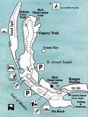
(Located about 10 miles south of Anclote Key)
You can get there by car, from the Dunedin Causeway,
Admission to the park the last time i went was $4, but well
worth it.
Caladesi Island State park is located just south of honeymoon
island and is also a great island to kayak to, you cannot however
get to Caladesi by car.
Honeymoon Island is a link in the chain
of barrier islands that extends from Anclote Key south to Cape
Romano and cushions the Florida coast from tropical storms.
Geologically speaking, the island is a relative youngster -
only 7,000 years old.
The men and women of the Tocobaga tribe
were its first recorded visitors. By 1530, Spanish explorers
had scanned the island's coast. For the next two centuries pirates,
traders and fisherman came and went. The Tocobagans, wiped out
by foreign diseases, stayed. Their bones reside in the low-lying
mounds on the adjacent islands.
By 1830 it was on the map as Sand Island.
The Hurricane of '48 drove 5' of water over it and a faltering
hog farm was at least successful enough for a name to change
to Hog Island by 1880. In 1921, another hurricane split the
island, forming Hurricane Pass and Caladesi Island to the south.
By 1970 environmental studies presented
enough evidence to halt any further dredging and filling. Four
years later, the Division of Recreation and Parks acquired the
remaining undeveloped 416 upland and 4,400 submerged acres of
Honeymoon Island. Dunedin donated its 22-acre
beach in 1982, and the island changed again - this time to one
of Florida’s showcase coastal recreation areas.
Visitors can observe one of the few remaining
south Florida virgin slash pine stands along the island’s
Osprey Trail. These large trees serve as important nesting sites
for the Osprey.
Other important coastal plant communities
found on and around the island include mangrove swamps, seagrass
beds, salt marshes, tidal flats, and sand dunes, Honeymoon Island
has more than 208 species of plants and a variety of shore birds
including several threatened and endangered species.
• Fishing can yield catches of flounder,
snook, trout, redfish, snapper, whiting, sheepshead and tarpon
• An operated ferry service provides transportation to
and from Caladesi Island State Park.
You can contact Honeymoon Island State
Park,
#1 Causeway Blvd., Dunedin, FL 34698
(727) 469-5942 |
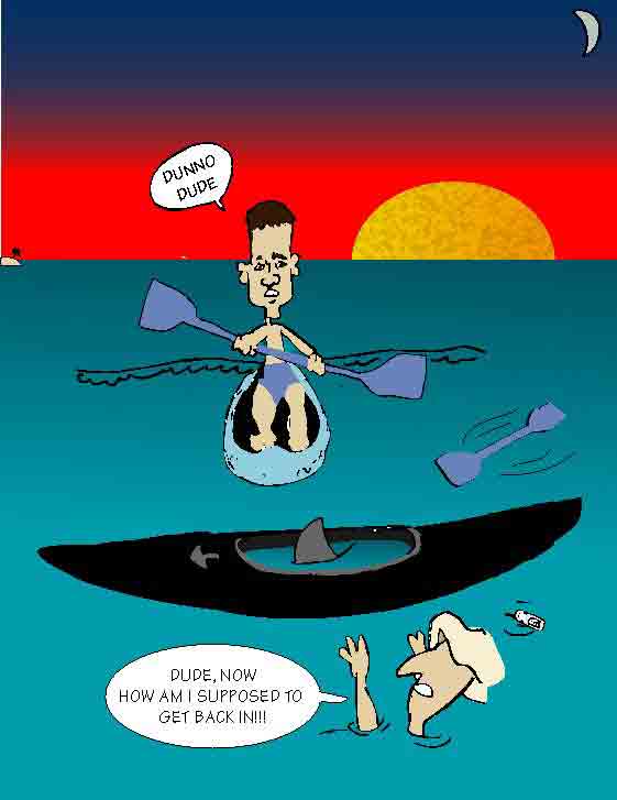 Don't
let this happen to you, stay in your kayak...
Don't
let this happen to you, stay in your kayak...